• Skip to primary navigation
  • Skip to main content
  • Skip to primary sidebar
  • Skip to footer

California Through My Lens

California Travel, Food, Hiking & Road Trips

  • Start Here
  • Explore
    • Beaches
    • Bizarre
    • Caves
    • Food
    • Hikes
    • Historical Structures
    • Natural Wonders
    • Waterfalls
  • Drive
    • El Camino Real
    • Highway 395
    • LA to Las Vegas
    • Pacific Coast Highway
    • Route 66
  • National Parks
    • Channel Islands
    • Death Valley
    • Joshua Tree
    • Lassen Volcanic
    • Pinnacles
    • Redwoods
    • Sequoia & Kings Canyon
    • Yosemite
  • Cities
    • Los Angeles
    • Palm Springs
    • Sacramento
    • San Diego
    • San Francisco
  • Resources
    • Day Trip Ideas
    • Road Trip eBooks
    • Hotels
    • My Favorite Travel Products
    • Travel Videos
  • Browse By …
    • Map Of Locations
    • Cities
    • Counties
    • National Parks
    • State Parks

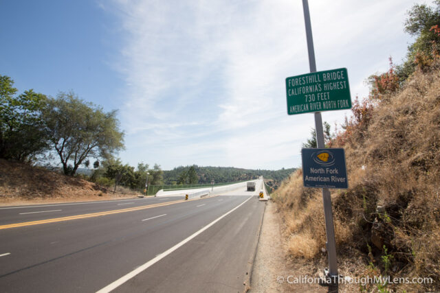
Foresthill Bridge: California’s Tallest Bridge

Last Modified: April 21, 2020

14shares
  • Share
  • Tweet

From the Golden Gate Bridge to Bixby Bridge, I love exploring all of the impressive bridges California has to offer. There are so many great ones to see that I wrote an entire post on them you can read here. The tallest of all of these bridges is the Foresthill Bridge, outside of Auburn. It stands at a massive 750 feet above the ground, and it is one of those bridges you really need to see to believe. Here is all of the info so that you can experience this achievement of human ingenuity from many different viewpoints.

Foresthill Bridge-8

Details

  • Cost: Free, $10 if you want to park at the state park below
  • Information from my visit in 2015 and 2018

Getting There

There are two unique spots to see the bridge from, above and below. Here is how I recommend seeing both.

Below

Foresthill Bridge-1

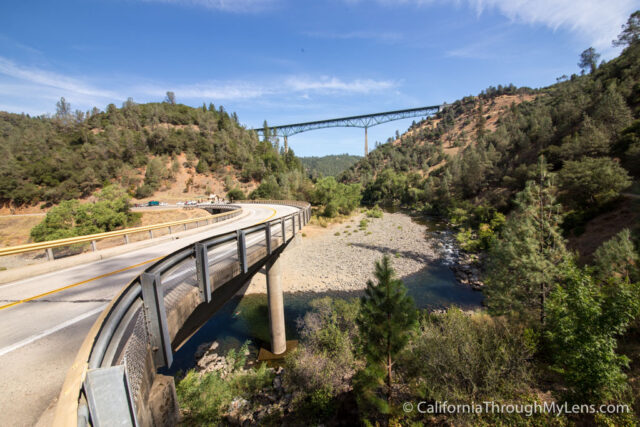
If you are traveling north from Sacramento, get off on Highway 49 south, right near downtown Auburn and proceed towards the city of Cool (yes, that is an actual city name). The road will wind down for a few miles before you see the first view of the bridge in the distance. Continue down this road until you see the turnoff towards the city of Cool. Right past this, you will see a tiny parking area for the state park below the bridge.

Foresthill Bridge-2

If you want to go on a few hikes, then park here and pay the $10 fee and explore. If not, you can pull off right when you pass the small bridge and then walk back about halfway on said bridge for a fantastic view of the Foresthill Bridge above. 
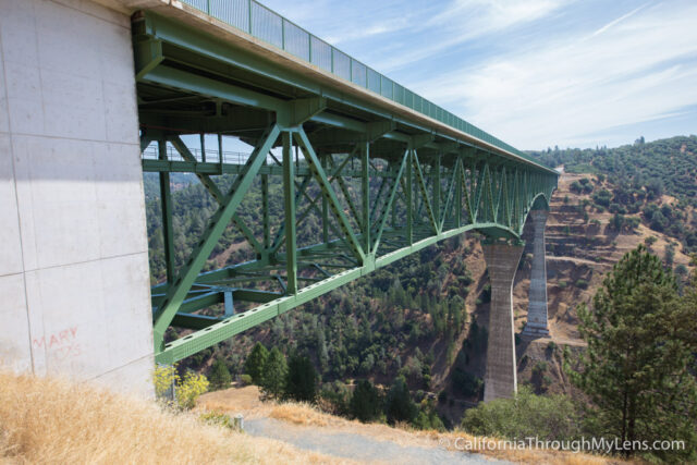
Foresthill Bridge-3

Above

After grabbing this shot, you will want to continue on the road up the mountain till it ends on Foresthill Rd. Turn left on this road and then drive a few miles before you cross the bridge itself. When you cross it, you can pull off on the left-hand side to explore. 

Foresthill Bridge-4

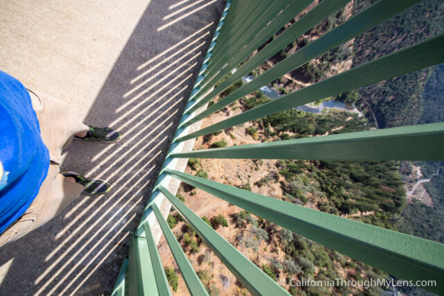
From here, I recommend walking out on the bridge to see how high it is. Of course, there is a big green fence that messes up your view, but it is still a pretty crazy thing to see.

Foresthill Bridge-10

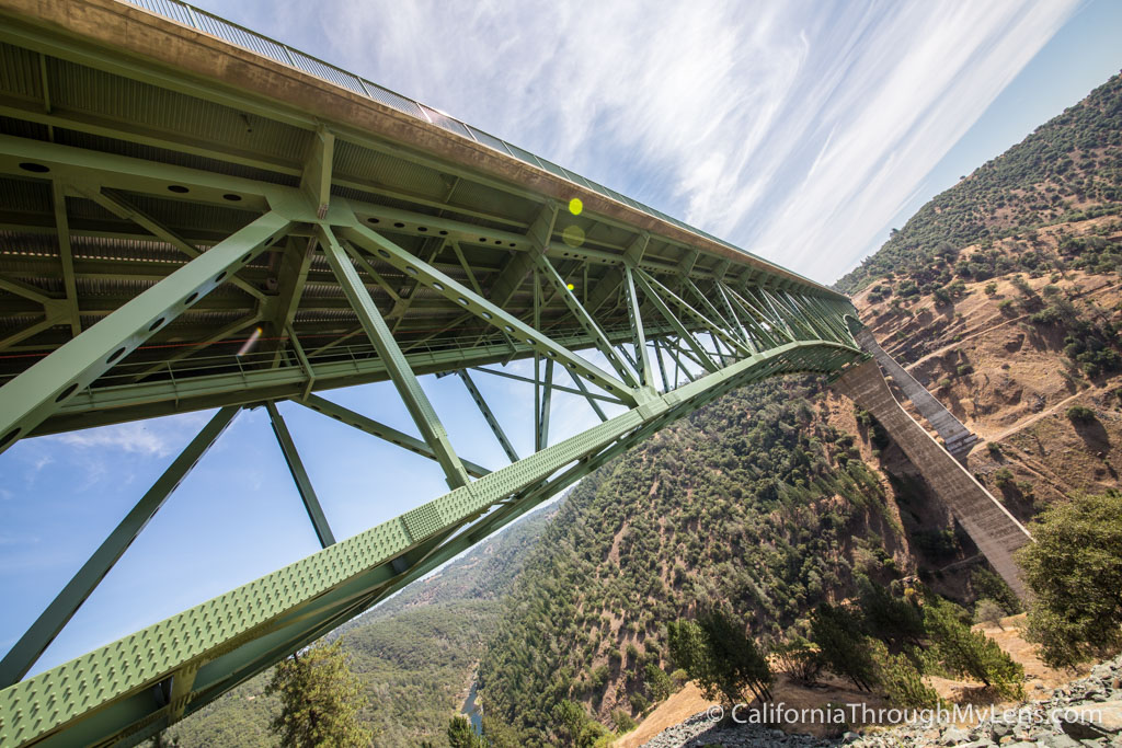
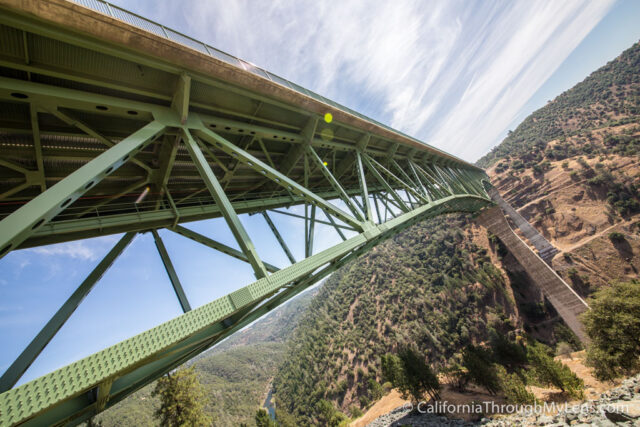
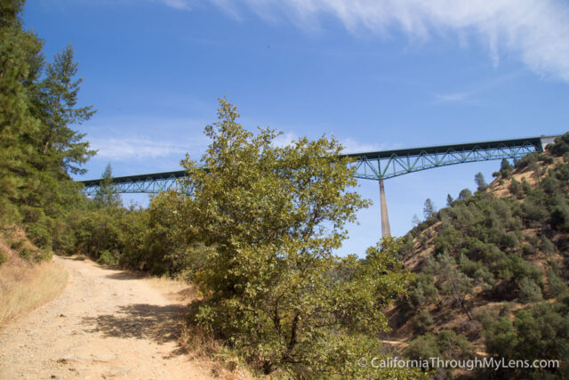
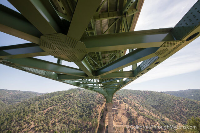
After walking out on the bridge, I headed down a small and steep single track next to the bridge, which connected with a large road. 

Foresthill Bridge-6

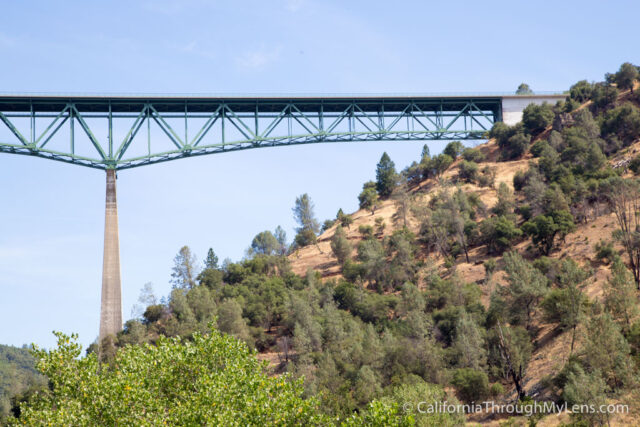
This dirt road let me go under the bridge for some additional photos, and from this angle, you really can see how amazing this bridge is.

Foresthill Bridge-7

After that, I climbed back up the slippery single track and walked back to my car. I wish I had more time to explore here as the mountains were all scared with hiking trails, so it seems to be a very popular spot for hiking. Let me know what your favorite hike is here, so I have an idea of what to do next time I come. 

Filed Under: Bridges, Northern California Tagged With: Auburn, Placer County

Interested in supporting this blog?

This blog is simply a hobby and labor of love for me. If you have enjoyed the posts consider sharing it with your friends. I want as many people as possible to explore this state and you can help by letting them know about all of the great spots!

Join the Newsletter

Subscribe for the four day welcome series and to get the latest content every month.

    We won’t send you spam. Unsubscribe at any time.

    About JoshMc

    Thanks for checking out the blog, I am happy to be sharing my adventures with you! You can get to know me by reading my about me, which includes a video and additional information on the site, myself and my full disclosure. Also, follow along on Twitter here or read all of my posts on this blog here.

    Primary Sidebar

    About

    Josh from California Through My Lens I'm a travel junkie strapped down to one state, focused on seeing as much of it as I can and encouraging others to do the same. More about me.

    Popular Posts

    The Big List of Strange, Fun & Unique Attractions in Southern California
    Pacific Coast Highway: Where to Stop on Your Road Trip
    Top Hiking Trails in Southern California
    Fun Stops on the Drive from Los Angeles to Las Vegas
    24 Things to do in Downtown LA
    17 Things to do in Lake Tahoe
    Donner Pass, Summit Tunnel Hike: Old Abandoned Railroad

    Categories

    Other Resources


    Footer

    Search the site

    Additional Information

    Privacy Policy

    About Us

    Copyright © 2021 · Metro Pro on Genesis Framework · WordPress · Log in

    Coronavirus January 2021 Update: Please note that some information in the posts may have changed and some places may be closed.