9 Great Hikes to Do in Siskiyou County
Siskiyou County sits at the northern top of California, right in the middle the state, and is bisected by the 5 highway. The county is rugged and wonderful, with some of the best hikes you can do in California. With the Trinity Alps Wilderness on one side and Mt Shasta and the caves of Lava Beds National Monument on the other, you could easily spend a lifetime exploring the wilderness in this part of the state. While this is by no means a complete list, and it focuses more on the easier hikes for those just getting into hiking, there is something for everyone in Siskiyou County and on this list. The list is in order of length, and let’s jump right into it.
This post was sponsored by Discover Siskiyou but all opinions are my own.
Video
Here is a video I made on all these hikes.
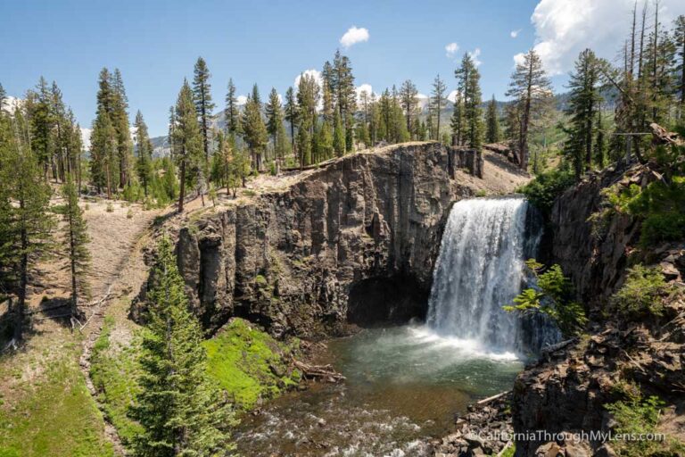
Hedge Creek Falls
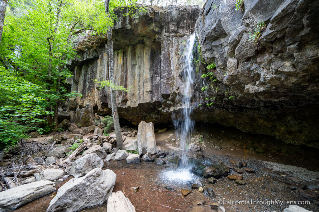
Hedge Creek Falls is an easy stop in the town of Dunsmuir that is great if you are looking for a way to stretch your legs on a road trip. The hike is around a half mile round trip, but it is scenic and steep in some sections. The trail leads down to a waterfall on a series of switchbacks. When you get to the waterfall, you can continue on the trail behind the water and over to the other side. It is unique to be able to go behind a waterfall like this, and it is one of those hikes that I have done many times and still love coming back to do again. If you are short on time, it is the most accessible introduction to the area you can find, and a spectacular waterfall to see after only 10 minutes of hiking.
Hedge Creek Falls Details
- .5 miles round trip
- Location: Dunsmuir
- Parking across from the trailhead
Box Canyon
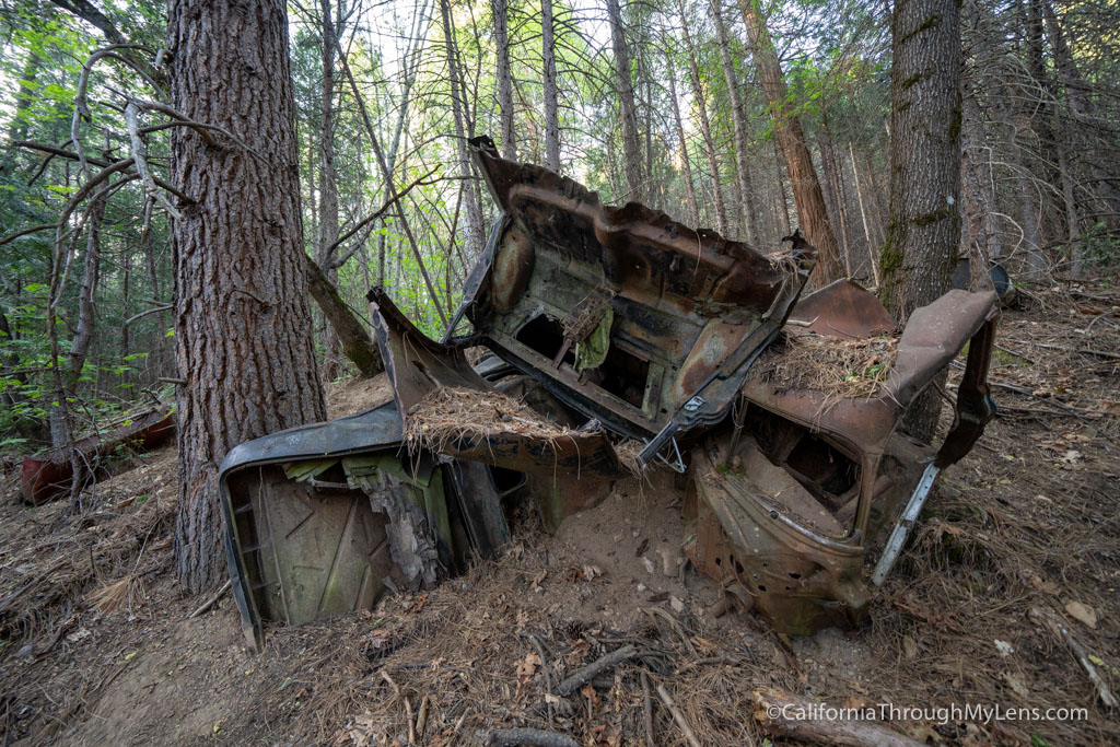
Box Canyon is a fun, family-friendly hike right near Lake Siskiyou that is a little over a mile round trip. The trail begins next to the Box Canyon Dam, and it takes you downhill as you parallel the creek next to you. Unfortunately, there are only short glimpses of the stream as most of the hike is shaded with lush trees. One of the highlights is all the old abandoned cars that you will see around the halfway point. Apparently, this part of Shasta used to be a dumping ground for cars, and there are dozens of them in different levels of deterioration along the trail. As you pass them, the trail continues through the beautiful trees and eventually ends at a small rock outcropping from which you can almost see the creek. It’s a nice path that never seems too busy in the area.
Box Canyon Details
- 1.2 miles round trip
- Location: Mt Shasta
- Parking in the lot near the lake, across from the trailhead
Spring Hill
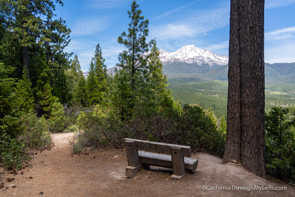
The Spring Hill Trail is located minutes from downtown Mt Shasta and is another excellent short hike for a quick road trip stop. The trail leaves from a parking area across the street from the Sacramento River Headwaters, and it climbs 650 feet to the top of Spring Hill. Along the way, there are benches to sit and relax at that look out towards Mt Shasta. This is a fantastic hike, and the views are stunning if it is clear. Do note that the views at the top are not very good, so the best views are on the way up. My favorite part of the trail is the view at Rocky Point, so consider taking the short hike to Rocky Point on the way back down the hill.
Spring Hill Details
- 2.5 miles round trip
- 650 feet of elevation gain
- Location: Mt Shasta
- Parking in the dirt lot near N Mt Shasta Blvd and Ski Village Drive
Lava Beds National Monument
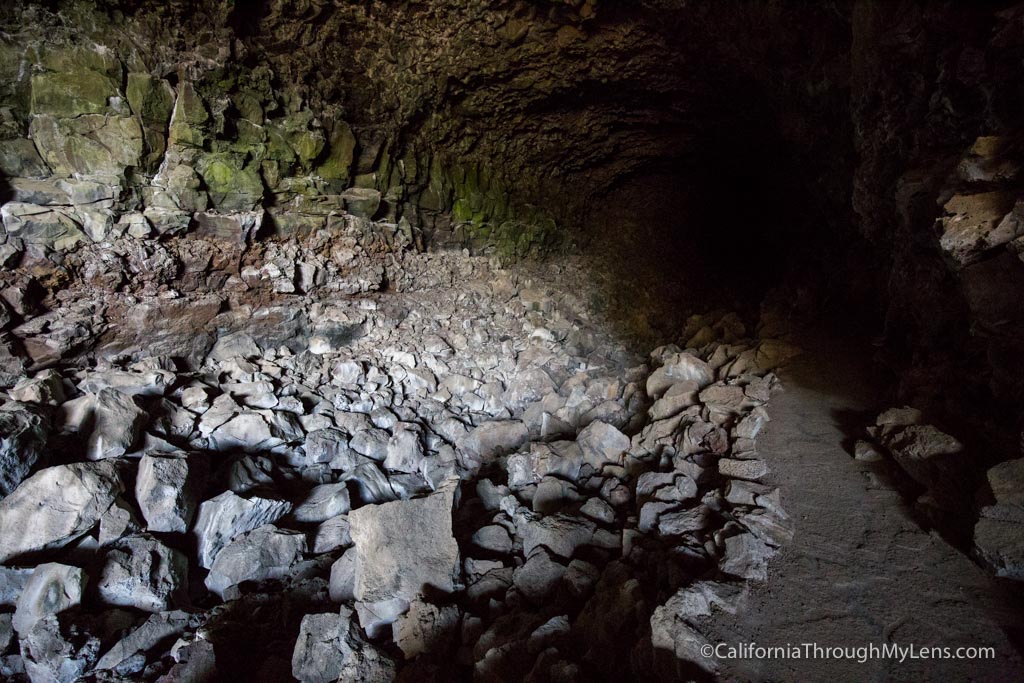
Lava Beds National Monument was hard to place on the list as the hikes there are all varying lengths, and you will want to do many of them if you make the drive out to the eastern part of the county. Lava Beds is impressive and features dozens of caves that you are free to explore with unique features like cave-ins that let in the light, a cave with almost a full mile of darkness, and one that has a golden appearance on the cave ceiling. You can drive the cave loop and get out at any you are interested in or check-in with the visitors center, and they will tell you some of the best for your ability level. Be sure to bring a flashlight though! I recommend you do Skull Cave, Sunshine Cave, and Sentinel Cave, but you will have fun doing any of them.
Lava Beds National Monument Details
- Dozens of miles of trails
- Location: Tulelake
- $25 to enter the park
Hidden Lake
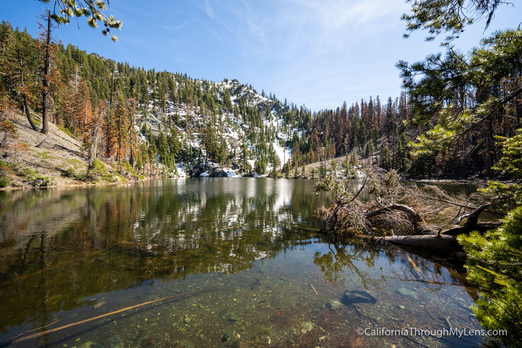
I didn’t want to not have the Trinity Alps Wilderness on this list, but most of the hikes there are long and remote, so they require a lot more effort than the average hiker will want to put in. That being said, the easiest way to get a taste of the Trinity Alps Wilderness is on the Hidden Lakes Trail. This trail is 2 miles round trip and takes you up to a stunning high-altitude lake. The area did get burned in a fire in 2021, so the path can be hard to find, and it is not as scenic as it once was. That being said, it is a fascinating area to explore, and the lake will probably make you want to spend more time in this unique part of the state.
Hidden Lake Details
- 1.8 miles round trip
- Location: Forks of Salmon (Trinity Alps Wilderness)
- Parking in the small lot at the trailhead
- All Trails map
McCloud Falls
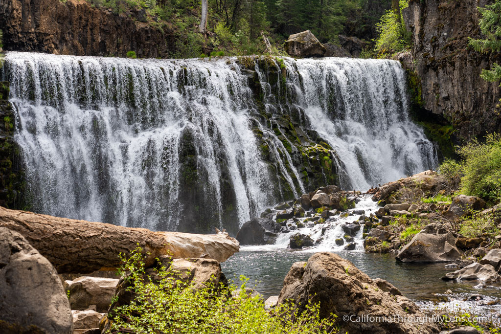
Heading to the town of McCloud in the southern part of the county, this hike is around 4 miles round trip and takes you to three waterfalls. The hike starts at the lower falls and follows the McCloud River as you head up to the other two waterfalls. My favorite is Middle Falls, which is as stunning as it gets for a California waterfall, but all three are worth seeing. If you don’t want to hike, you can also drive between the three, but if you’re going to see Middle Falls from the base, you will have to hike down to it from the overlook. Spend some time here, it is an excellent spot for a half-day, and in the winter, you can even snowshoe to the falls if that is something you are interested in.
McCloud Falls Details
- 3.9 miles round trip (can drive to the lookout for each waterfall)
- Location: McCloud
- Parking next to each overlook
Lake Siskiyou
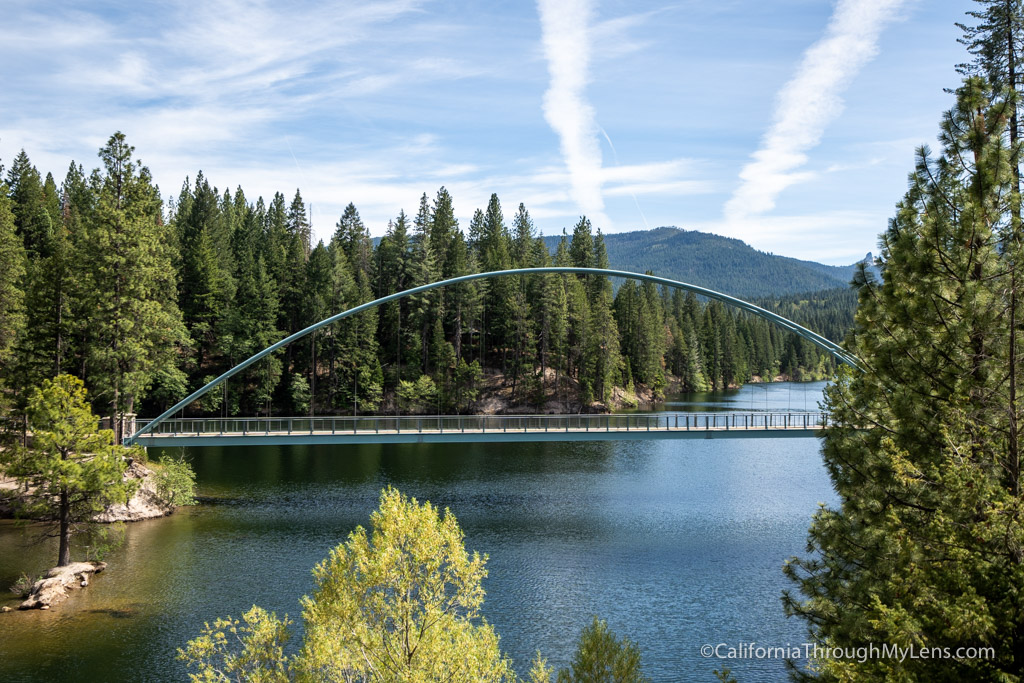
Lake Siskiyou is another great hike for all ages as it can be as long as 7 miles to get around the whole lake, or it can be short if you simply want to park at one of the lots and hike around. The lake is spectacular and has so many amazing views that it is worth exploring. If it is clear, you will see Mt Shasta towering above you as you make your way around the west side of the lake. Be sure to also go across the fantastic pedestrian bridge they have in the northeast section of the lake. It is great to see an awesome bridge like this just built for pedestrian access and is a unique feature on the trail. Let me know what your favorite part of the lake is in the comments.
Lake Siskiyou Details
- 7 miles round trip
- Location: Mt Shasta
- Parking lots at many access points around the lake
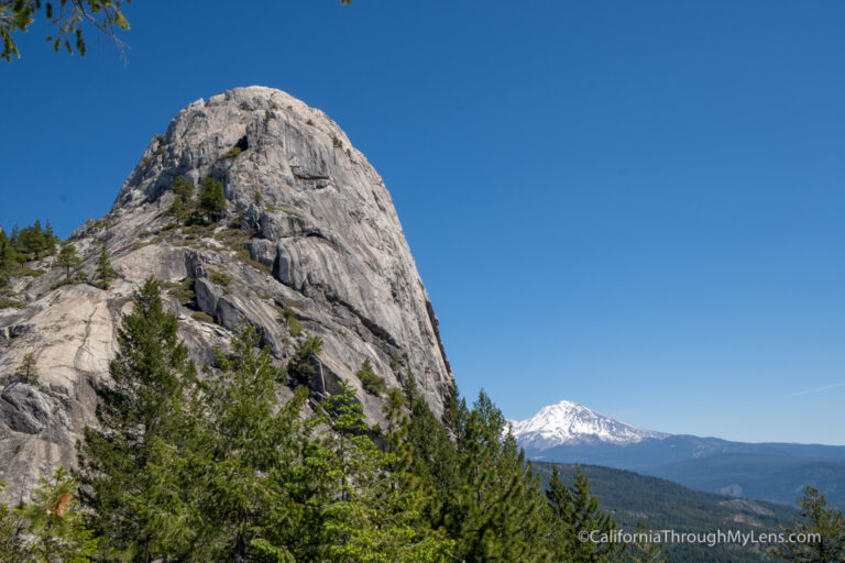
Castle Dome
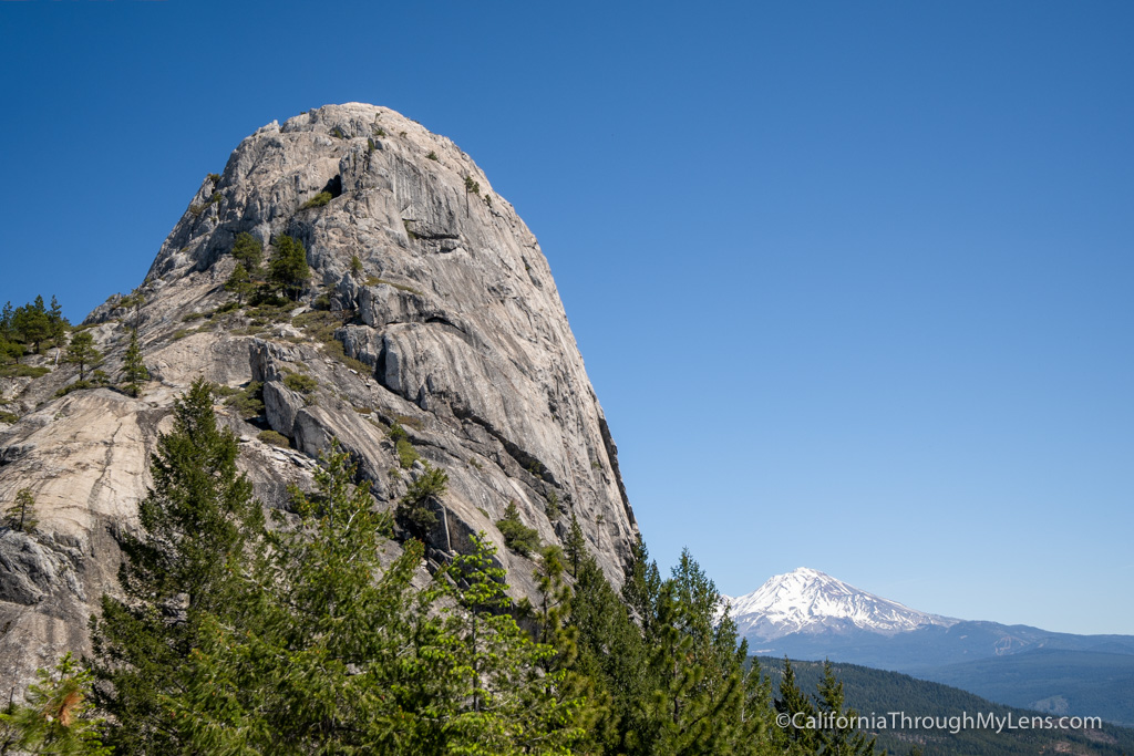
Castle Dome is located in Castle Crags State Park, a stunning and often overlooked state park right on Highway 5. The park has an amazing collection of craggy rocks as the focal point, but it is hard to see them without a lot of work, which is why the park doesn’t get a lot of visitors. The main hike takes you through a lush forest and up to the park’s main feature, Castle Dome. Castle Dome is a massive granite monolith that you can only summit with ropes but which looks across at Mt Shasta on a clear day. Even if you don’t want to climb to the top, the trail takes you up to the rocks and lets you explore to your heart’s content. However, it is a tough hike, with the last mile climbing over 1,000 feet on uneven stones. The views from the top easily make it worth it though. I heard there are more great hikes in the park so let me know if you have one I should try next time!
Castle Dome Details
- 5.2 miles round trip
- Location: Dunsmuir
- $10 to enter the park
- Parking lot near the visita point
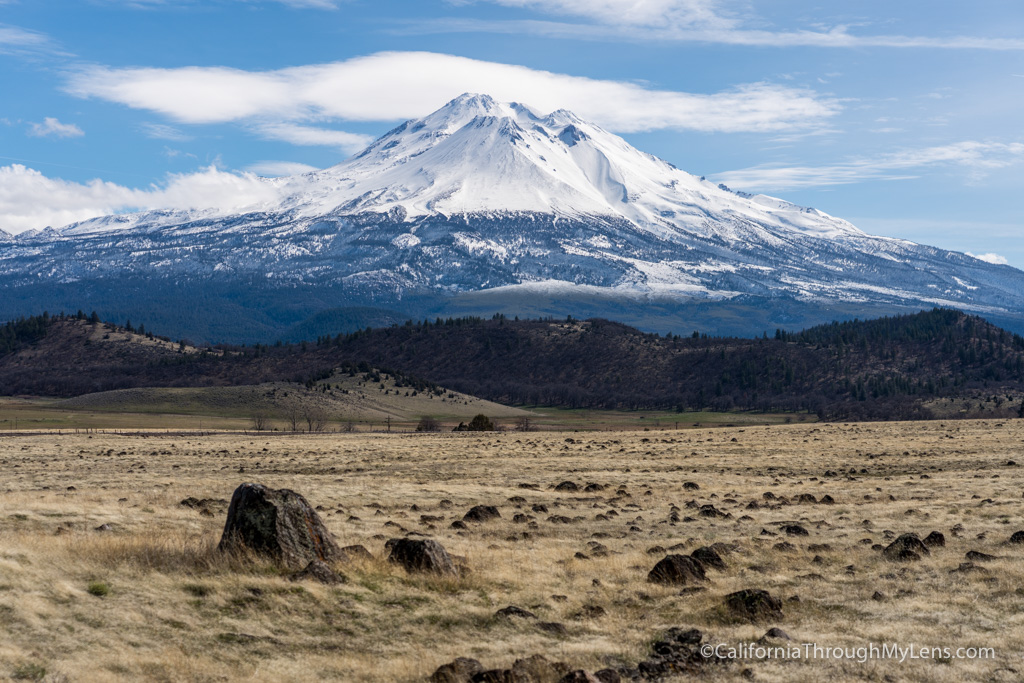
Mt Shasta

I know that most people watching this video (or reading this post) probably won’t want to undertake the mammoth hike that is Mount Shasta. Still, I wanted to include it as it is iconic and the focal point of Siskiyou County. This 14,000-foot volcano is most often climbed in the late spring when the weather is more favorable, and there is still some snow cover, making the climb more technical yet easier to traverse. We did it in 2018 over two days, and it was one of the best and hardest California adventures I have ever done. Some of the highlights were seeing the mountain’s shadow as we were hiking the Red Banks section, standing on the windy summit, and getting to glissade down some of the steeper parts at the end. If you are interested in the full climb, there is another video on my channel detailing it.
Mt Shasta Details
- 1.5 miles round trip (7,000 feet of elevation)
- Location: Mt Shasta
- Parking at Bunny Flats
- Technical trail and should not be done without training and preparation
There you have it, some of my favorite hikes in Siskiyou County. Hopefully you can check out a few of these and that you fall in love with the area like I have. Let me know what I left off in the comments!

Hotel recommendation
Inn at Mt Shasta
The Inn at Mt Shasta is a great home base for exploring Siskiyou County. The hotel recently went through a renovation and it is a a fun and modern spot right in the heart of Mt Shasta.